Consainsights logo
Background Image

Mobile Mapping Market Report

Mobile-Mapping Market by Product (Software, Hardware, Services), Application (Transportation, Construction, Urban Planning, Environmental Monitoring, Other Applications) and Region – Analysis on Size, Share, Trends, COVID-19 Impact, Competitive Analysis, Growth Opportunities and Key Insights from 2023 to 2030.

01 Executive Summary

Mobile Mapping Market Size & CAGR

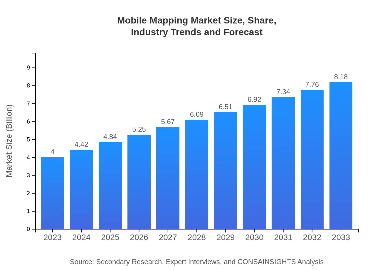
The Mobile Mapping market size is projected to reach USD 12.5 billion by 2023. The Compound Annual Growth Rate (CAGR) of the Mobile Mapping market is expected to be 9.2% from 2023 to 2030. The forecast growth rate indicates a promising outlook for the market, driven by the increasing demand for geospatial data and mapping technologies across various industries.

COVID-19 Impact on the Mobile Mapping Market

The COVID-19 pandemic has significantly impacted the Mobile Mapping market. With travel restrictions, supply chain disruptions, and economic uncertainties, the market witnessed a temporary slowdown in 2020. However, the pandemic also accelerated the adoption of remote mapping technologies and virtual surveying tools. As businesses adapted to remote work environments, the demand for accurate mapping solutions for urban planning, infrastructure development, and disaster response grew.

Mobile Mapping Market Dynamics

The Mobile Mapping market is influenced by various dynamics, including technological advancements, regulatory policies, and industry trends. The integration of artificial intelligence, LiDAR sensors, and satellite imagery has transformed the way mobile mapping is conducted. Market players are focusing on developing user-friendly mapping applications that offer real-time data visualization and analysis capabilities. Regulatory guidelines related to data privacy and security also impact the market dynamics, driving companies to adhere to stringent standards to protect sensitive information.

Segments and Related Analysis of the Mobile Mapping market

The Mobile Mapping market can be segmented based on technology, product, application, and end-user. Technologies such as GPS, LiDAR, and photogrammetry play a crucial role in mobile mapping applications. Products like mobile mapping software and hardware solutions cater to different industry requirements. Mapping applications include navigation, geospatial analysis, urban planning, and asset management. Various end-users, including government agencies, surveying companies, and transportation companies, rely on mobile mapping solutions for efficient data collection and analysis.

Mobile Mapping Market Analysis Report by Region

Asia Pacific Mobile Mapping Market Report

The Asia Pacific region is experiencing significant growth in the mobile mapping market due to rapid urbanization, infrastructure development, and smart city initiatives. Countries like China, Japan, and India are key players in the market, driving innovation in mapping technologies and applications. The increasing adoption of drones and aerial surveying techniques has further boosted the demand for mobile mapping solutions in the region.

South America Mobile Mapping Market Report

South America has seen a surge in mobile mapping applications across industries such as agriculture, mining, and environmental monitoring. The region's diverse terrain and natural resources require advanced mapping technologies for resource management and conservation efforts. Companies in South America are investing in mobile mapping solutions to streamline operations and enhance decision-making processes.

North America Mobile Mapping Market Report

North America remains a key market for mobile mapping, driven by the presence of leading technology companies and government initiatives for digital mapping projects. The region is at the forefront of developing LiDAR-based mapping solutions for autonomous vehicles, smart infrastructure, and precision agriculture. Market players in North America are focused on expanding their product portfolios and enhancing geospatial data analytics capabilities.

Europe Mobile Mapping Market Report

Europe is a mature market for mobile mapping, with established players offering a wide range of mapping solutions for industries like construction, transportation, and utilities. The European Union's emphasis on environmental sustainability and digital transformation has led to increased investments in mobile mapping technologies for monitoring land use, energy infrastructure, and natural hazards. Market competition in Europe is intense, driving innovation and product differentiation among key players.

Middle East and Africa Mobile Mapping Market Report

The Middle East and Africa region are witnessing a rapid adoption of mobile mapping solutions for urban planning, land surveying, and disaster management. Countries like Saudi Arabia, the UAE, and South Africa are investing in advanced mapping technologies to support infrastructure development and smart city initiatives. The region's diverse landscape and growing infrastructure projects present opportunities for mobile mapping vendors to expand their presence and offer tailored solutions to local markets.

Mobile Mapping Market Analysis Report by Technology

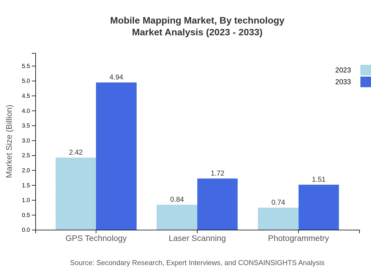
The mobile mapping market can be analyzed based on various technologies, including GPS, LiDAR, photogrammetry, and others. GPS technology is widely used for location-based services and navigation applications. LiDAR sensors enable high-precision 3D mapping for infrastructure projects and environmental monitoring. Photogrammetry techniques are utilized for aerial mapping and terrain modeling. Advancements in sensor technology and data processing algorithms have revolutionized mobile mapping capabilities, offering real-time data acquisition and analysis for diverse applications.

Mobile Mapping Market Analysis Report by Product

Mobile mapping products encompass software platforms, hardware devices, and integrated solutions tailored to specific industry needs. Mapping software provides tools for data visualization, analysis, and reporting, enabling users to create custom maps and generate actionable insights. Hardware components like LiDAR scanners, GPS receivers, and cameras are essential for data collection and sensor fusion in mobile mapping systems. Integrated solutions combine software and hardware elements to deliver comprehensive mapping solutions for navigation, asset tracking, and geospatial analysis.

Mobile Mapping Market Analysis Report by Application

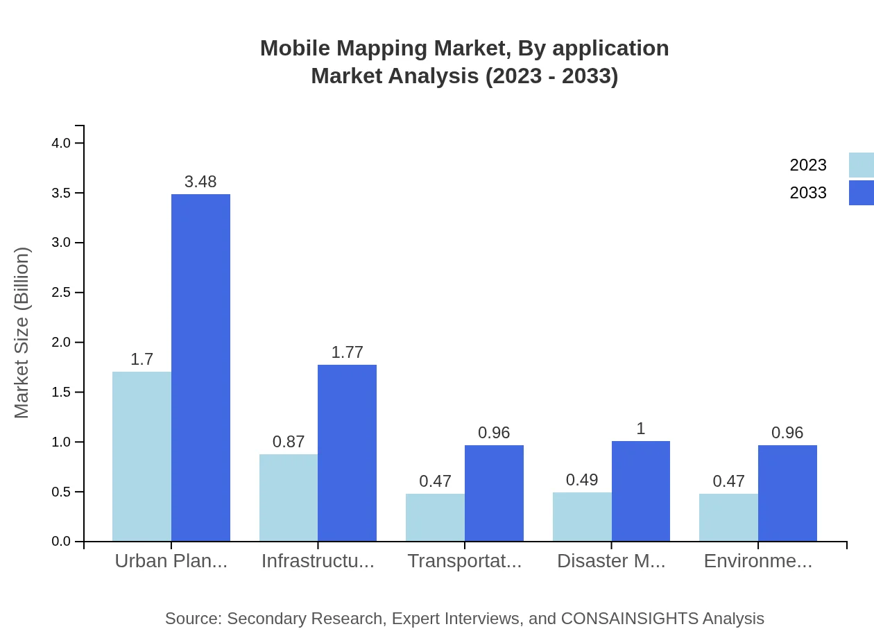
Mobile mapping applications span a wide range of industries and use cases, including urban planning, transportation, agriculture, environmental monitoring, and disaster response. Urban planning applications leverage mobile mapping data for infrastructure design, land use analysis, and smart city development. Transportation agencies rely on mapping solutions for route optimization, traffic management, and fleet tracking. Agriculture uses mobile mapping for precision farming, soil analysis, and crop monitoring. Environmental organizations utilize mapping technologies for habitat mapping, biodiversity assessment, and conservation planning. Disaster response teams deploy mobile mapping tools for emergency mapping, risk assessment, and recovery efforts in crisis situations.

Mobile Mapping Market Analysis Report by End-User

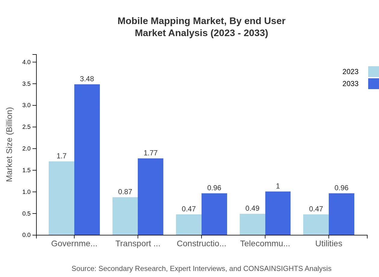
End-users of mobile mapping solutions include government agencies, surveying companies, construction firms, transportation providers, utility companies, and others. Government agencies use mobile mapping for urban development, emergency management, and cadastral mapping. Surveying companies rely on mapping technologies for land surveying, aerial mapping, and cadastral surveys. Construction firms utilize mobile mapping for site planning, monitoring, and asset management. Transportation providers integrate mapping solutions for route planning, fleet management, and public transit services. Utility companies deploy mobile mapping for infrastructure maintenance, asset tracking, and network planning. Each end-user segment has specific requirements and challenges that drive the adoption of mobile mapping technologies tailored to their needs.

Key Growth Drivers and Key Market Players of Mobile Mapping Market

Key growth drivers of the Mobile Mapping market include the increasing demand for real-time spatial data, advancements in sensor technologies, and the proliferation of location-based services. Market players like Google, Apple, Trimble, Hexagon, and HERE Technologies are leading the mobile mapping industry with innovative mapping solutions, strategic partnerships, and acquisitions. These companies leverage AI, machine learning, and cloud computing to enhance mapping accuracy, coverage, and usability for a wide range of applications. The competitive landscape of the mobile mapping market is characterized by continuous innovation, product diversification, and geographic expansion, as companies compete to gain market share and meet evolving customer demands.

Mobile Mapping Market Trends and Future Forecast

The mobile mapping market is evolving rapidly, driven by emerging trends such as indoor mapping, autonomous driving, augmented reality, and digital twins. Indoor mapping solutions are gaining traction in retail, healthcare, and hospitality sectors for indoor navigation, facility management, and customer engagement. Autonomous driving technologies rely on high-definition maps and real-time localization for vehicle guidance, obstacle detection, and path planning. Augmented reality applications integrate mobile mapping data with visual overlays for immersive user experiences in gaming, tourism, and education. Digital twins simulate real-world environments using mobile mapping data for urban planning, infrastructure modeling, and virtual prototyping. These trends indicate a future where mobile mapping technologies will play a central role in shaping smart cities, connected vehicles, intelligent buildings, and personalized experiences.

Recent Happenings in the Mobile Mapping Market

Recent developments in the Mobile Mapping market include strategic partnerships, product launches, and acquisitions by key players to enhance their market presence and offerings. Companies like Trimble introduced new LiDAR sensors for mobile mapping applications, enabling high-precision data collection for infrastructure projects and environmental monitoring. Google announced updates to its Google Maps platform, incorporating real-time traffic data, satellite imagery, and indoor mapping features for enhanced user experiences. HERE Technologies partnered with automotive manufacturers to integrate HD mapping solutions into autonomous vehicles, enabling safe and efficient navigation in complex environments. These developments highlight the dynamic nature of the mobile mapping market and the ongoing innovation shaping the future of geospatial technologies.

02 Research Methodology

Our research methodology entails an ideal mixture of primary and secondary initiatives. Key steps involved in the process are listed below:

  • Step 1. Data collection and Triangulation

    This stage involves gathering market data from various sources to ensure accuracy and comprehensiveness.

  • Step 2. Primary and Secondary Data Research

    Conducting in-depth research using both primary data (interviews, surveys) and secondary data (reports, articles) to gather relevant information.

  • Step 3. Data analysis

    Analyzing and interpreting the collected data to identify patterns, trends, and insights that can inform decision-making.

  • Step 4. Data sizing and forecasting

    Estimating the size of the market and forecasting future trends based on the analyzed data to guide strategic planning.

  • Step 5. Expert analysis and data verification

    Engaging subject matter experts to review and verify the accuracy and reliability of the data and findings.

  • Step 6. Data visualization

    Creating visual representations such as charts and graphs to effectively communicate the data findings to stakeholders.

  • Step 7. Reporting

    Compiling a comprehensive report that presents the research findings, insights, and recommendations in a clear and concise manner.

Data collection and Triangulation

The foundation is meticulous data gathering from multiple primary and secondary sources through interviews, surveys, industry databases, and publications. We critically triangulate these data points, cross-verifying and correlating findings to ensure comprehensiveness and accuracy.

Primary and Secondary Data Research

Our approach combines robust primary research discussion with industry experts and an exhaustive study of secondary data sources. A comprehensive analysis of published information from credible databases, journals, and market research reports complements direct interactions with industry stakeholders and key opinion leaders.

Data analysis

With a wealth of data at our disposal, our seasoned analysts meticulously examine and interpret the findings. Leveraging advanced analytical tools and techniques, we identify trends, patterns, and correlations, separating signal from noise to uncover profound insights that shed light on market realities.

Data sizing and forecasting

Armed with a profound understanding of market dynamics, our specialists employ robust statistical models and proprietary algorithms to size markets accurately. We go a step further, harnessing our predictive capabilities to forecast future trajectories, empowering clients with foresight for informed decision-making.

Expert analysis and data verification

Our research findings undergo a rigorous review by a panel of subject matter experts who lend their deep industry knowledge. This critical analysis ensures our insights are comprehensive and aligned with real-world dynamics. We also meticulously verify each data point, leaving no stone unturned in our pursuit of accuracy.

Data visualization

To unlock the true potential of our research, we employ powerful data visualization techniques. Our analysts transform complex datasets into intuitive visuals, including charts, graphs, and interactive dashboards. This approach facilitates seamless communication of key insights, enabling stakeholders to comprehend market intricacies at a glance.

Reporting

The final step is providing detailed reports that combine our in-depth analysis with practical advice. Our reports are designed to give clients a competitive edge by clearly explaining market complexities and highlighting emerging opportunities they can take advantage of.

03 Market Overview

Market Definition and Scope
Market Segmentation
Currency
Forecast
Assumptions

Market Definition and Scope

The Mobile Mapping Market refers to the technological framework and service model that enables the significant accumulation of geospatial data using mobile-based systems. This market encompasses a variety of applications ranging from cartography to urban planning, utilizing sophisticated sensors and data processing capabilities.

Mobile mapping systems have evolved to integrate various types of geolocation technologies and sensors, including LiDAR, GPS, and digital cameras, to capture, analyze, and visualize spatial data efficiently. The definition of this market has grown to incorporate innovations in autonomous vehicles, drones, and smartphone technologies that simplify and enhance the data collection process.

As smart cities and infrastructure systems grow in demand, the relevance of mobile mapping becomes increasingly pivotal. Stakeholders in various industries, including transportation, utilities, and telecommunications, are recognizing mobile mapping as an essential tool for enhancing operational efficiency and making informed decisions based on real-time geospatial insights.

The scope of the mobile mapping market is further broadening due to advancements in artificial intelligence and machine learning techniques, which are facilitating automated processing and analysis of mapped data. Such enhancements can optimize workflows and produce higher quality geospatial intelligence while reducing the turnaround time for data processing.

It is critical to clarify the parameters of this market by identifying key players, technological developments, and regional dynamics influencing growth. A comprehensive understanding of mobile mapping in terms of its definition and scope enables businesses and researchers alike to navigate the evolving landscape of geospatial data utilization.

Market Segmentation

The Mobile Mapping Market can be segmented based on various criteria, including technology type, component, application, and geography. Each segment reports distinct characteristics and trends that influence market dynamics. A sophisticated analysis of these segments provides insights for stakeholders across the board.

Technology-wise, the market can be divided into LiDAR, photogrammetry, and GNSS-based mapping systems. LiDAR, with its high precision and 3D modeling ability, is widely used in topographic surveys and environmental monitoring, attracting significant investment from government and private sectors. On the other hand, photogrammetry, utilizing images for mapping applications, is growing in popularity due to its cost-effectiveness and ease of use coupled with innovative software solutions.

Furthermore, when considering the component segmentation, one can categorize the market into hardware, software, and services. The hardware segment, particularly, includes specialized equipment such as 3D scanners and cameras, which are crucial for capturing accurate geospatial data. Conversely, the software segment encapsulates tools that process, analyze, and visualize the collected data, which are experiencing heightened demand for interoperability and ease of use.

Application-based segmentation reveals that the mobile mapping market serves various niches, such as construction, transportation, and urban planning. The construction sector utilizes mobile mapping for site surveys, terrain analysis, and progress tracking, while transportation agencies employ it for routing optimization and infrastructure maintenance.

Regional segmentation further enriches the analysis, allowing for the distinction between emerging markets and developed economies. Regions such as North America and Europe lead in mobile mapping adoption, mainly due to their advanced infrastructure and technological prowess, while Asia-Pacific is witnessing exponential growth fueled by urbanization and smart city initiatives.

Currency

In terms of currency, the Mobile Mapping Market operates primarily in U.S. dollars, offering a standardized framework for financial analysis and investment consideration for stakeholders globally. Pricing strategies, market valuations, and revenue estimations are intrinsically linked to the dollar value, as it serves as a universal benchmark.

The use of dollars as the primary currency in this industry facilitates consistency in financial reports and projections, thereby attracting global investments and enabling easier comparisons between different market players. This dollar-centric approach also aids stakeholders in mitigating the effects of currency fluctuations that can impact profitability and market positioning.

Moreover, considering the diverse regional segments of the market, businesses typically conduct thorough exchange rate assessments to analyze how currency fluctuations alter their operational costs in foreign markets. Organizations frequently implement hedging strategies to offset potential risks associated with currency volatility when engaging in cross-border transactions.

Understanding the influence of currency dynamics on the Mobile Mapping Market is essential for making informed strategic decisions, ensuring pricing models remain competitive while accommodating local economic conditions.

Overall, currency plays a significant role in shaping investment opportunities and market accessibility. It underscores the importance of a well-rounded financial strategy that factors in both global trends and regional economic dependencies in a fluid market landscape.

Forecast

Forecasting the future of the Mobile Mapping Market necessitates a keen appreciation of the trends currently at play and the anticipated technological advancements. Analysts predict a robust growth trajectory as businesses increasingly leverage mobile mapping solutions for diverse applications ranging from asset management to emergency response systems.

As urbanization continues to prompt the development of smart cities, the demand for sophisticated mobile mapping technologies is expected to surge. The integration of mobile mapping with artificial intelligence and machine learning will likely accelerate, allowing for real-time data processing and analytics which enhance operational decision-making across sectors.

Furthermore, the expanding use of unmanned aerial vehicles (UAVs) for data collection is poised to contribute to market growth diversely, making mobile mapping more accessible and efficient in surveying large and hard-to-reach areas. With regulatory frameworks around drone operations solidifying, companies can expect heightened opportunities for investment and innovation.

Market forecasts also suggest an upsurge in mobile mapping adoption among small to medium enterprises (SMEs), driven by decreasing technology costs and the democratization of data analysis tools. As these businesses recognize the value of geospatial data in driving business intelligence, they will increasingly turn to mobile mapping solutions.

In conclusion, the forecast for the Mobile Mapping Market is overwhelmingly positive, with estimates indicating substantial growth in market size, driven by technological advancements, expanding applications, and a shifting competitive landscape characterized by innovation and improved service offerings.

Assumptions

The analysis of the Mobile Mapping Market operates on several foundational assumptions that impact scenario planning and decision-making. These assumptions are critical for setting realistic expectations and creating strategic roadmaps for stakeholders involved in this dynamic environment.

One key assumption is the ongoing technological advancement in mobile mapping systems, which is anticipated to drive increased accuracy and efficiency in geospatial data collection. Analysts presume that innovations will continue to emerge, propelled by industry demand and competition, leading to more integrated and user-friendly solutions.

Another important assumption is related to regulatory support for UAVs and other mapping technologies. The expectation is that as regulations stabilize, the barriers to entry for new market players will lower, fostering a more competitive landscape. This confidence in regulatory developments encourages investment and research into advanced mapping solutions.

Further assumptions center around the evolving needs of various industries that increasingly recognize the value of geospatial data. Businesses will continue to seek out mobile mapping applications for tasks ranging from infrastructure development to disaster management, therefore driving up demand for seamless data integration and real-time analytics capabilities.

Lastly, it is assumed that there will be a rising trend towards eco-friendly and sustainable practices in data collection processes. As environmental awareness continues to grow, the market may shift towards technologies and methods that minimize ecological footprints, potentially reshaping industry standards and practices.

04 Market Dynamics

Market Drivers
Market Restraints
Market Opportunities
Market Challenges

Market Drivers

The rapid advancements in technology are significantly driving the mobile mapping market. As GPS and LiDAR technologies continue to evolve, mobile mapping systems are becoming more accurate and efficient. This technological advancement enables better data collection processes, making it easier for industries such as construction, transportation, and urban planning to adopt mobile mapping solutions.

Furthermore, the growing demand for Geographic Information Systems (GIS) is fueling the market growth. Organizations are increasingly recognizing the value of spatial data for decision-making and operational efficiency. Mobile mapping provides high-quality spatial data that can be quickly processed, analyzed, and integrated into GIS tools, thereby enhancing overall productivity.

Additionally, the rising need for real-time data and visualization in various sectors is another crucial driver. In industries such as transportation and logistics, having access to real-time information regarding routes and traffic conditions is vital for optimizing operations. Mobile mapping allows for the continuous updating of maps and geographical data, ensuring that businesses remain agile and informed.

The increasing trend of smart city initiatives worldwide also contributes to the mobile mapping market's growth. As cities strive to enhance livability and sustainability, accurate mapping becomes essential for urban planning and management. Mobile mapping solutions provide precise data that can be utilized to monitor infrastructure, assess environmental changes, and improve public services.

Lastly, government investments in infrastructure development and urbanization initiatives are significant market drivers. Governments are increasingly implementing projects that require meticulous mapping for planning and execution. This demand from public sector projects paves the way for mobile mapping technologies to be adopted more widely, thus driving market growth.

Market Restraints

Despite the promising growth of the mobile mapping market, there are notable restraints that could hinder its progress. One of the major challenges is the high cost associated with deploying mobile mapping systems. The initial investment required for acquiring advanced hardware and software solutions can be prohibitive, especially for small and medium-sized enterprises. This financial barrier can limit the market potential and deter some organizations from embracing technology.

Another significant restraint is the complexity of data processing and analysis. Mobile mapping generates vast amounts of data that must be accurately processed to derive meaningful insights. The need for skilled personnel proficient in data analytics, as well as sophisticated software solutions, can pose a challenge for many organizations, generating additional costs and resource allocation issues.

Additionally, there are concerns regarding privacy and data security. As mobile mapping often involves capturing images and data from public spaces, there are potential risks associated with data misuse or breaches. Public resistance to surveillance and privacy invasion could lead to regulatory restrictions, thereby inhibiting market development and user adoption.

Moreover, the dependence on technological infrastructure poses a challenge. In many regions, especially developing areas, the lack of adequate technological infrastructure, such as high-speed internet and advanced hardware capabilities, can limit the effectiveness of mobile mapping systems. This disparity poses a significant hurdle to the widespread implementation of mobile mapping solutions.

Lastly, competition from alternative mapping solutions can restrain the growth of mobile mapping. As the industry evolves, new technologies and platforms may emerge, offering distinct advantages over traditional mobile mapping techniques. This competition could divert potential clients and investments away from the mobile mapping sector.

Market Opportunities

In the face of existing restraints, several lucrative opportunities lie ahead for the mobile mapping market. One of the foremost opportunities is the integration of artificial intelligence (AI) and machine learning into mobile mapping systems. By leveraging these technologies, companies can enhance data analysis capabilities, allowing for predictive analytics and more intelligent decision-making processes that cater to user needs.

The increasing demand for 3D mapping solutions presents further opportunities for market expansion. As various industries aim to improve their visualization capabilities, the need for detailed and accurate 3D maps grows. Mobile mapping systems capable of producing high-quality 3D representations can capture a significant share of this emerging market trend.

Furthermore, the growing implementation of autonomous vehicles provides a promising opportunity for mobile mapping. As self-driving technology develops, accurate and comprehensive mapping becomes increasingly essential for navigation and safety. Mobile mapping can play a crucial role in mapping road networks and environmental conditions needed for the successful integration of autonomous vehicles in urban settings.

Moreover, the rise of innovative applications such as augmented reality (AR) and virtual reality (VR) creates new avenues for mobile mapping solutions. As industries explore new ways to engage with spatial data through immersive technologies, partnerships with AR and VR firms could lead to the development of novel applications, enhancing the mobile mapping service offerings.

Lastly, expanding into untapped markets like environmental monitoring and disaster management also represents a significant growth opportunity. As environmental concerns escalate and the frequency of natural disasters increases, the need for precise mapping for risk assessment and vegetation analysis grows. Mobile mapping can provide valuable support in these sectors by facilitating better planning and response strategies.

Market Challenges

While the mobile mapping market has ample growth potential, several challenges must be addressed for sustained success. A primary challenge is keeping pace with rapid technological evolution. As new technologies emerge, mobile mapping providers must continuously upgrade their systems and offerings to remain competitive. This constant need for innovation can strain resources and create pressure to maintain market relevance.

Another challenge is the standardization of data formats across different platforms. With various mobile mapping systems and technologies in play, establishing common data standards is critical for interoperability. The lack of standardized formats can lead to compatibility issues and data silos, thereby limiting the full utilization of mobile mapping data across various applications.

Additionally, the issue of skilled workforce availability poses a challenge. As the demand for mobile mapping solutions increases, the shortage of skilled professionals in data analysis, GIS, and geospatial technologies can become pronounced. Organizations may struggle to attract and retain talent, hindering their ability to fully utilize mobile mapping capabilities.

The evolving regulatory landscape around data privacy and geospatial data usage also presents a significant challenge. As regulations become stricter, mobile mapping companies must navigate complex legal frameworks to ensure compliance. Failure to adhere to new regulations can lead to legal ramifications and damage to reputations.

Finally, adapting to the varying requirements across different industries can be challenging. Each sector may have unique needs and expectations from mobile mapping technologies. Understanding and customizing solutions to fit these diverse requirements can be resource-intensive, requiring continuous engagement and collaboration with potential clients.

06 Regulatory Landscape

Overview of Regulatory Framework
Impact of Regulatory Policies on Market Growth

Overview of Regulatory Framework

Mobile mapping involves the use of various technologies, including GPS, laser scanning, and imaging, to create detailed maps and spatial data. The regulatory framework governing mobile mapping is multifaceted and primarily serves to ensure safety, privacy, and data integrity. Regulatory bodies at both national and international levels are engaged in establishing standards and protocols that govern how mobile mapping technologies can be deployed and utilized.

In the United States, for instance, the Federal Aviation Administration (FAA) plays a critical role in regulating the use of drones for mapping purposes. Recent changes to drone regulations have expanded the scope of operations allowed for commercial use, which has encouraged innovation in mobile mapping technologies. However, companies must still adhere to strict compliance measures, including licensing and operational safety standards, which may vary by state.

Privacy considerations are another crucial aspect of the regulatory landscape. As mobile mapping technologies can gather vast amounts of data, including images of individuals and private properties, regulations such as the General Data Protection Regulation (GDPR) in Europe set high standards for data collection, usage, and sharing. Companies must ensure that their mapping practices do not infringe on personal privacy rights and that they are transparent about how data is collected and utilized.

Internationally, there are organizations working to harmonize regulations for mobile mapping technologies. Standards set by the International Organization for Standardization (ISO) and the International Telecommunication Union (ITU) seek to facilitate cross-border data sharing and mapping practices. This is particularly significant for global businesses that rely on accurate and timely spatial data from multiple jurisdictions, necessitating compliance with varying legal environments.

Overall, the regulatory landscape for mobile mapping is continuously evolving, driven by technological advancements and societal needs. Stakeholders in this field must stay apprised of regulatory changes to navigate compliance effectively, ensuring that their innovations contribute to safety, privacy, and the overall enhancement of urban and rural planning processes.

Impact of Regulatory Policies on Market Growth

The impact of regulatory policies on the mobile mapping market is profound and far-reaching. Effective regulations can foster innovation and growth within the sector, while overly restrictive laws may stifle development and deter investment. Policymakers are increasingly recognizing the potential of mobile mapping technologies to enhance infrastructure management, urban planning, and logistics, leading to a more supportive regulatory environment in many regions.

For example, the easing of certain drone operation regulations has spurred a significant uptick in the use of drones for mapping applications. Companies are now able to deploy drones for surveying and monitoring purposes with relative ease, encouraging investment into advanced sensor technologies and software analytics. This shift has created new business opportunities and led to a more competitive market landscape that benefits consumers through improved services and lower costs.

Conversely, stringent regulations can pose challenges to market growth. In some jurisdictions, compliance costs associated with obtaining necessary permits for mobile mapping can be prohibitively high, particularly for startups and small businesses. This can limit the entry of new players into the market, reducing competition and hindering innovation. Consequently, regulatory bodies must strike a balance between ensuring safety and privacy while also promoting a vibrant landscape for mobile mapping technologies.

Another aspect of regulatory impact is the emphasis on data privacy and protection. The demand for compliance with legislation like GDPR has prompted companies in the mobile mapping sector to invest in more robust data management and protection protocols. While this may increase operational costs, it can also drive technological advancements, leading to the development of new solutions that enhance data security, ultimately benefiting the market and consumers.

In conclusion, the regulatory policies governing mobile mapping play a critical role in shaping market dynamics. By promoting a balanced approach that considers safety, privacy, and innovation, regulators can significantly influence market growth trajectories and ensure that mobile mapping technologies are used effectively for the benefit of society as a whole.

07 Impact of COVID-19 on the Artificial Intelligence Market

Short-term and Long-term Implications
Shift in Market Dynamics
Consumer Behavior

Short-term and Long-term Implications

The COVID-19 pandemic has significantly disrupted various sectors across the globe, and the mobile mapping market is no exception. In the short term, many companies involved in mobile mapping faced halted projects due to lockdown measures, travel restrictions, and an overall decline in economic activity. This immediate impact caused supply chain disruptions and delays in project completions, as teams could not operate efficiently. Additionally, companies had to pivot quickly to remote working environments, which altered the traditional workflows associated with data collection and processing in the field.

However, these short-term implications were quickly intertwined with long-term trends. As restrictions started to ease, a growing number of businesses and governments recognized the value of technology in maintaining operations during crises. Mobile mapping solutions proved crucial for infrastructure management, urban planning, and disaster response strategies, leading to increased demand as sectors adapted to new realities. Thus, companies began to invest in enhancing their technologies to provide more robust solutions that could operate under a variety of conditions.

Furthermore, the increased focus on contactless services and automation has presented both a challenge and an opportunity for the mobile mapping market. The need for enhanced safety protocols has accelerated the adoption of technologies such as LiDAR and drone mapping, which offer safer alternatives for data collection without compromising quality. In the longer term, this could lead to a transformation in the types of services offered within the mobile mapping space, as companies diversify their approaches to meet new consumer preferences and safety standards.

Moreover, as organizations explore ways to implement social distancing measures, the potential emergence of hybrid models combining traditional methods with advanced technology is on the rise. This means that mobile mapping services may evolve not just in terms of execution but also in how they engage with clients and stakeholders throughout the process. Future technologies may integrate real-time data sharing and visualization tools, enabling remote collaboration and enhancing productivity.

By understanding these implications, companies within the mobile mapping market can strategize accordingly to remain resilient amid ongoing uncertainties. Long-term investments in technology and training, along with agility in operations, will be key for firms looking to capitalize on the industry’s recovery and growth trajectory.

Shift in Market Dynamics

The onset of the COVID-19 pandemic has not only created challenges but has also led to a shift in the dynamics of the mobile mapping market. As companies adapt to the new normal, there is an evident uptick in demand for mobile mapping solutions that facilitate remote infrastructure monitoring and data collection. This demand spiked as many organizations began prioritizing the need for accurate, real-time mapping data without necessitating extensive on-site presence.

In the wake of the pandemic, various industries have recognized the value of mobile mapping not just for traditional applications (such as cartography or construction), but for broader uses such as urban planning, environmental monitoring, and even healthcare logistics. Consequently, the market has expanded to accommodate these diverse applications, attracting new entrants and fostering innovation among existing players. The stakes have never been higher for companies to distinguish themselves through technological advancements and bespoke solutions tailored to the needs of clients in this evolving landscape.

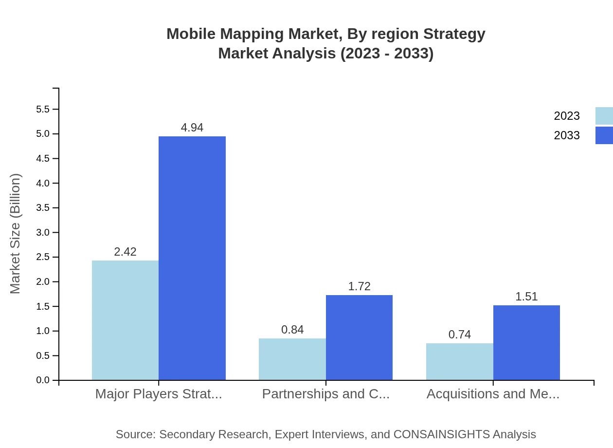
Additionally, the competition landscape within the mobile mapping market is experiencing a transformation. As more organizations seek mobile mapping services, providers are prompted to rethink their strategies. Some have embraced partnerships and collaborations, merging expertise and resources to enhance service offerings, while others focus on acquisitions to broaden their technological capabilities. These shifts are shaping a more dynamic environment in which companies must depend on not only the quality of their technologies but also on the agility of their business models.

Data and analytics have also taken center stage in this new market dynamic. The vast quantities of data collected through mobile mapping solutions present a wealth of opportunities for organizations that can analyze and leverage this information. Companies that offer integrated solutions that combine mapping with predictive analytics or machine learning stand to gain a competitive edge as clients seek data-driven insights to make informed decisions about their operations.

In conclusion, the COVID-19 pandemic has spurred significant shifts in market dynamics within the mobile mapping sector. As demand for innovative, flexible, and precise mapping solutions rises, companies must adapt to the changing landscape. The successful players will likely be those who not only respond to emerging needs with agility but who also proactively shape the future of mobile mapping through technological advancements and strategic collaborations.

Consumer Behavior

The pandemic has brought about substantial changes in consumer behavior, reshaping how businesses approach their clients in the mobile mapping market. Customers are increasingly seeking solutions that prioritize not only quality and efficiency but also safety and flexibility. As consumers become more aware of the risks associated with on-site engagements, they are more likely to favor service providers that can demonstrate robust health and safety protocols.

Furthermore, the shift towards digital transformation and remote work has heightened expectations regarding the speed and accessibility of mapping solutions. Consumers now expect real-time data and faster turnaround times, making it essential for mobile mapping companies to harness technology effectively. This evolution reflects a broader trend where end-users prioritize immediacy and convenience in all aspects of their interactions with service providers.

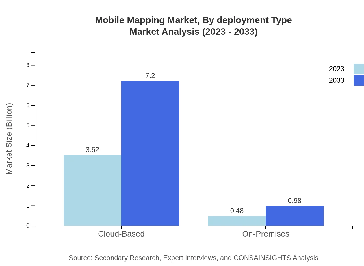
Additionally, as organizations pivot to embrace remote work policies, there has been a greater emphasis placed on collaborative tools. Consumers in the mobile mapping space look for integrated solutions that facilitate seamless sharing and visualization of data across teams. The rise of cloud-based platforms and mobile applications signifies a shift towards more collaborative environments where real-time updates and information sharing have become fundamental to decision-making processes.

The pandemic has also spurred increased consumer scrutiny regarding sustainability and social responsibility. Clients are evaluating their suppliers based not only on service efficiency but also on their environmental footprints and contributions to social causes. This has prompted many mobile mapping companies to adopt greener practices and incorporate sustainability into their service offerings to meet the evolving expectations of discerning consumers.

In summary, the impact of COVID-19 has prompted a profound transformation in consumer behavior within the mobile mapping market. As more individuals and organizations navigate a changing environment, their priorities are shifting towards demands for safety, efficiency, and sustainability. Companies that recognize and adapt to these changes will position themselves for sustained success in an increasingly competitive landscape.

08 Porter's Five Forces Analysis

Bargaining Power of Suppliers
Bargaining Power of Buyers
Threat of New Entrants
Threat of Substitutes
Competitive Rivalry

Bargaining Power of Suppliers

The mobile mapping market heavily relies on suppliers for hardware components, software technologies, and data services. The bargaining power of suppliers varies based on the concentration of suppliers in the market and the uniqueness of their offerings. With a limited number of suppliers offering specialized technology, such as Lidar systems and advanced imaging sensors, these suppliers can exert significant pressure on mobile mapping companies regarding pricing and contract terms.

Moreover, suppliers that provide proprietary software tools for mapping and data analysis can further increase their bargaining power. Companies utilizing mobile mapping technologies must navigate the complexities of software licensing, which can limit their flexibility and increase operational costs. In industries where rapid advancements in technology are prevalent, suppliers who lead in innovation can dictate product timelines and influence overall market dynamics.

Even though the number of potential suppliers is expanding, many firms prefer to partner with established players due to reliability and support services. This creates a power imbalance favoring the suppliers, especially those offering integrated solutions that combine hardware and software.

Furthermore, suppliers' control over the supply chain can pose additional challenges. Disruptions in the supply of essential components can lead to increased costs or production delays. In response, companies may attempt to diversify their supplier base or invest in vertical integration to gain more control over critical supply channels, thereby reducing supplier power.

Ultimately, the bargaining power of suppliers in the mobile mapping market indicates a critical area for companies to monitor. Addressing the leverage of suppliers through strategic partnerships and fostering competitive supplier options may enhance a company's position in negotiations and operational flexibility.

Bargaining Power of Buyers

The bargaining power of buyers in the mobile mapping market is notably influenced by the growing number of service providers and the availability of alternative solutions. This power shifts significantly as more companies emerge with competitive offerings, enabling buyers to easily switch providers if their requirements are not met. Increased competition has led to heightened expectations for pricing, service quality, and technological innovation from buyers.

Companies looking to deploy mobile mapping solutions often compare various market offerings before making a decision. As buyers become more informed about product functionalities and pricing structures, they leverage this knowledge to negotiate better deals. Businesses aiming to enhance their mobile mapping capabilities find themselves with an array of choices, which can further empower their negotiation positions.

The segmentation of buyers into different categories such as governmental agencies, construction companies, and logistics firms exemplifies the diverse needs that impact bargaining power. For instance, large governmental contracts can sway vendors to provide concessions in price or additional features, while smaller businesses may find it harder to secure favorable terms due to their lower buying volume.

Furthermore, technological advancements have amplified buyers' expectations for integration and customization, further demanding that mobile mapping providers adapt quickly to meet specific application needs. Buyers often demand tailored solutions that align with their operational workflows, which adds complexity to the supplier-buyer relationship, compelling suppliers to invest in customer outreach and tailored service plans.

Ultimately, the changing landscape of the mobile mapping market signifies that companies must stay attuned to the evolving power dynamics associated with buyers. Strong buyer power mandates continuous improvements in service offerings, technological upgrades, and customer support to maintain competitive advantages and customer loyalty.

Threat of New Entrants

The mobile mapping market presents a moderate to high threat of new entrants, as advancements in technology and the decreased cost of entry make it easier for new companies to launch innovative services. Technological progress in Geographic Information Systems (GIS), sensor technology, and data processing has democratized access to mobile mapping capabilities, encouraging aspiring firms to enter this lucrative market.

However, the high initial costs associated with research and development, infrastructure setup, and specialized workforce training can deter some potential entrants. Established players have proliferated their market presence, benefitting from brand recognition, established customer relationships, and economies of scale, which pose significant barriers for new entrants seeking to capture market share.

Moreover, regulatory requirements and compliance considerations related to data privacy and mapping practices can also hamper the entry of newcomers. New entrants must navigate these complex regulatory landscapes, which can increase operational complexity and costs and necessitate expert legal guidance, ultimately acting as a deterrent for a portion of prospective competitors.

Despite these challenges, the potential for startups to leverage cutting-edge technologies like Artificial Intelligence (AI) and cloud computing in mobile mapping applications remains an enticing draw. These innovations provide new entrants with opportunities to carve out niche markets or differentiate themselves through unique service offerings.

In conclusion, while the threat of new entrants continues to exist in the mobile mapping market, the combination of barriers such as high upfront costs, regulatory complexities, and the advantage of established players mitigates the risk posed by new competitors. Existing companies should continuously innovate and reinforce their competitive positions to stay ahead.

Threat of Substitutes

The threat of substitutes in the mobile mapping market arises from the rapidly advancing technologies that can serve as alternatives to traditional mobile mapping solutions. These substitutes may include fixed mapping installations, photogrammetry, aerial mapping technologies, and emerging personal mapping applications. Businesses looking to gather spatial data often evaluate these alternatives based on factors like cost, accuracy, and efficiency.

As technology evolves, many substitutes can match or exceed the accuracy and usability of mobile mapping systems. These developments compel companies in the mobile mapping space to adopt innovations continuously or risk obsolescence. For instance, drones equipped with high-resolution cameras and Lidar technology offer compelling substitutes, providing comparable mapping data from an aerial perspective, often with decreased operational costs.

Moreover, some industries may find that conventional surveying methods or technological solutions like satellite imagery can suffice for their mapping needs. This poses a challenge since potential buyers may choose these substitutes that provide sufficient quality at lower prices. Consequently, mobile mapping companies must highlight the distinct advantages of their offerings, such as real-time data capture and increased efficiency, to maintain their position in the market.

Another factor influencing the threat of substitutes is the changing preferences of consumers who seek more integrated and automated solutions. The rise of DIY mapping tools and applications for personal use represents another challenge for mobile mapping providers, as these tools can often provide satisfactory results for smaller projects without requiring professional services.

In summary, while substitutes pose a notable threat to the mobile mapping market, companies that focus on innovation, highlighting unique selling propositions, and adapting to consumer preferences can successfully mitigate these risks over time. Continuous improvement and value addition may separate mobile mapping solutions from substitutes, ensuring their demand remains strong.

Competitive Rivalry

Competitive rivalry in the mobile mapping market is intense, with numerous firms striving for a share of the ever-expanding sector. The competitive landscape encompasses a range of players, from established companies with comprehensive portfolios to specialized startups focusing on niche applications. This segmentation creates a dynamic market where innovation and differentiation are key factors driving competition.

Given the technological advancements characterizing the mobile mapping industry, companies must continuously evolve and enhance their product offerings to stay competitive. Rivals are actively investing in Research and Development (R&D) to innovate in sensor technology, data processing capabilities, and user-friendly software applications. As a result, companies are compelled to allocate significant resources towards new technological advancements to capture and retain customers.

Furthermore, the strategies employed by competitors recognize the importance of customer service and support. Firms that are able to provide superior customer experience, technical assistance, and tailored solutions develop stronger brand loyalty in comparison to rivals. This customer-centric approach is crucial for maintaining competitiveness in an industry driven by rapid technological shifts.

Prices are also a critical element of competitive rivalry, as firms attempt to attract new customers and retain existing ones. The pressure to remain price competitive without compromising on quality can lead to price wars, challenging the profitability of companies in the sector. This aspect demands careful balance and strategic pricing models to sustain profitability while remaining attractive to buyers.

In conclusion, the mobile mapping market is characterized by fierce competitive rivalry, compelling firms to develop innovative solutions, maintain exemplary customer service, and implement strategic pricing. As market dynamics continue to evolve, only companies that embrace continuous improvement and adopt forward-thinking strategies will thrive and maintain a sustainable competitive advantage.

09 Key Insights and Findings

Overview
Technological Advancements
Market Trends
Challenges
Future Outlook

Overview

The mobile mapping market has gained significant traction over recent years due to advancements in technology and increasing demand for geospatial data. This market encompasses a range of solutions that integrate various technologies such as GPS, LiDAR, and imaging sensors to capture geospatial information through mobile platforms. As businesses and governments look to enhance their operational efficiencies and decision-making processes, the mobile mapping market continues to expand.

One of the primary drivers of this market is the exponential growth of the smartphone and mobile device industry. As smartphones become more advanced, their capabilities to collect and process geospatial data have improved drastically. This has created opportunities for various applications, from urban planning and infrastructure management to autonomous vehicles and environmental monitoring.

Moreover, the increased awareness of the benefits of geographic information systems (GIS) is propelling the mobile mapping market forward. GIS technology enables better visualization, analysis, and interpretation of spatial data, which is invaluable in industries such as construction, real estate, and environmental management. Consequently, organizations are investing in mobile mapping technologies to leverage GIS for practical applications.

Another factor contributing to the market growth is the rising demand for real-time data and analytics. The ability to capture and process data in real time significantly enhances decision-making processes across various sectors, thereby driving the adoption of mobile mapping solutions. Companies can optimize their operations, improve service delivery, and respond to changes in the market efficiently by utilizing real-time geospatial data.

Overall, the mobile mapping market is on a robust growth trajectory with a multitude of applications across diverse industries. Future innovations in related technologies, such as artificial intelligence and machine learning, are expected to further enhance the capabilities of mobile mapping solutions, allowing for faster, more accurate data collection and analysis.

Technological Advancements

Technological advancements are at the cornerstone of the mobile mapping market's transformation. The integration of technologies such as LiDAR, 3D modeling, and sensor fusion has revolutionized data collection methods. LiDAR systems, for instance, provide high-resolution spatial data which is crucial for applications demanding precision, such as forestry management and urban development.

Additionally, the emergence of drone technology has significantly impacted the capabilities of mobile mapping solutions. Drones equipped with advanced mapping sensors can cover large areas quickly and efficiently, providing comprehensive geospatial data that was previously time-consuming and costly to obtain. This enhances the ability of organizations to undertake large-scale surveying projects and infrastructure assessments with ease.

Furthermore, with the evolution of artificial intelligence, the processing of mapping data is becoming more sophisticated. AI algorithms can analyze large datasets derived from mobile mapping technologies, allowing for pattern recognition, anomaly detection, and predictive modeling. These capabilities empower businesses to derive actionable insights that can lead to more informed strategic decisions.

Moreover, the development of cloud computing technology facilitates easier storage and sharing of geospatial data collected from mobile mapping tools. This enhances collaboration and accessibility across teams and departments, enabling better-integrated workflows and project management. Real-time data can be processed in the cloud, providing instant access to stakeholders regardless of their location.

As these technological advancements continue to unfold, the mobile mapping market is expected to see even more innovative solutions that will expand its applications. Industries must remain adaptable to fully leverage these technologies, ensuring they stay ahead of the competition in an increasingly data-driven world.

Market Trends

Several key market trends are shaping the mobile mapping industry. One such trend is the increasing user-friendliness of mobile mapping applications. Developers are focusing on creating intuitive platforms that allow users without advanced technical skills to harness mobile mapping technology. This democratization of technology is expanding user bases and facilitating widespread adoption.

Another trend seen in the market is the growing interest in integrating mobile mapping solutions with augmented reality (AR). AR applications can overlay geospatial data onto real-world views, providing users with enhanced situational awareness. This is particularly useful in sectors such as logistics and agriculture, where real-time insights into physical environments can improve operational efficiency.

Additionally, the rise of autonomous vehicles is significantly influencing the mobile mapping landscape. The demand for high-definition maps is critical for the safe navigation and operation of these vehicles. Mobile mapping technologies are essential to gather the rich data needed to create these detailed maps, pushing further innovation in the area.

Moreover, organizations are becoming increasingly aware of the importance of sustainability and environmental responsibility. Mobile mapping technologies are playing a critical role in smart city initiatives and environmental assessments. The ability to collect accurate environmental data aids cities in regulating pollution, managing resources, and planning for sustainable development.

In summary, the mobile mapping market is dynamically evolving due to various trends that emphasize user accessibility, integration with new technologies, and a focus on sustainability. As these trends continue to gain momentum, they will redefine how businesses and governments utilize geospatial data for planning and operational enhancement.

Challenges

Despite the favorable growth trajectory of the mobile mapping market, several challenges remain prevalent. One of the prominent challenges is the data privacy and security concerns associated with collecting and processing geospatial data. Organizations must navigate strict regulations regarding data protection, which can complicate implementation and deter potential users from adopting mobile mapping technologies.

Moreover, the technical complexity of mobile mapping solutions can pose a barrier to entry for many businesses. Smaller firms may lack the resources or technical expertise required to develop or maintain these advanced solutions, limiting their ability to compete effectively in the market. There's a growing need for simplified, off-the-shelf solutions that enable widespread adoption among various industry players.

In addition, variability in data quality remains a challenge that hampers the reliability of mobile mapping outputs. Differences in equipment capabilities, operational conditions, and user expertise can lead to inconsistencies in data collection and processing. Standardization across the industry is necessary to ensure that data collected from mobile mapping technologies is accurate and comparable.

Furthermore, integration issues can arise when attempting to merge mobile mapping data with existing systems and processes within organizations. Companies need to invest in custom solutions or undergo significant operational changes to accommodate new technologies, which can be resource-intensive and daunting.

Ultimately, addressing these challenges will require concerted efforts from stakeholders across the mobile mapping ecosystem. Collaborative approaches to developing standards, enhancing technical support, and ensuring compliance with data privacy regulations will be essential in navigating these obstacles and unlocking the full potential of the mobile mapping market.

Future Outlook

The future outlook for the mobile mapping market is optimistic, as advancements in technology continue to pave the way for innovative applications and solutions. The integration of technologies such as artificial intelligence, machine learning, and big data analytics will empower mobile mapping solutions to deliver even greater value to users, enhancing their ability to derive insights from geospatial data.

As various industries become increasingly aware of the strategic advantages of leveraging mobile mapping technologies, the demand is expected to surge. Businesses across sectors such as construction, transportation, and agriculture are anticipated to adopt mobile mapping solutions to drive efficiency, improve operational workflows, and enhance decision-making processes.

Additionally, the growing importance of smart cities and sustainable development initiatives is likely to fuel investments in mobile mapping technologies. As cities strive to become more efficient and environmentally friendly, accurate geospatial data will be critical in guiding infrastructure planning, resource management, and urban development.

Moreover, with the proliferation of autonomous and connected vehicles, there will be an escalating need for high-definition mapping solutions. Mobile mapping technologies will play a pivotal role in supplying the data required to support safe navigation and operation of these vehicles, further expanding the scope of the market.

In conclusion, the mobile mapping market is poised for significant growth, driven by technology advancements, increasing demand across various industries, and the ongoing pursuit of sustainable urban development. Stakeholders who proactively embrace these trends and challenges will undoubtedly position themselves for success in the evolving landscape of mobile mapping.

10 Technology Overview

LiDAR Technology
GPS Technology
Imaging and Photogrammetry
Data Processing Technologies
Other Mapping Technologies

LiDAR Technology

LiDAR, or Light Detection and Ranging, is a remote sensing technology that utilizes laser light to measure distances. The process involves sending rapid pulses of laser light towards the ground and measuring how long it takes for each pulse to bounce back. This technology is pivotal in creating precise, three-dimensional information about the physical characteristics of the Earth and its surface.

The accuracy of LiDAR systems is one of their most significant advantages, typically achieving centimeter-level precision. This accuracy is essential for various applications, including topographic mapping, forestry management, and urban planning. As industries increasingly demand more reliable and detailed data, LiDAR's prominence within the mobile mapping market continues to grow.

Beyond just distance measurement, LiDAR technology can generate high-resolution digital elevation models (DEMs) and provide insights into vegetation structure, land use, and changes in terrain. The ability to conduct surveys in a much shorter time frame than traditional methods—sometimes delivering results in real-time—enhances the operational effectiveness of LiDAR systems in mobile mapping applications.

LiDAR’s utility is further amplified when coupled with GPS technology, allowing for georeferencing of the data collected. This integration leads to improved accuracy in positioning and mapping projects, leading to more informed decision-making in sectors such as construction, disaster management, and environmental monitoring.

The versatility of LiDAR technology extends to various platforms, including aerial, terrestrial, and mobile devices. This adaptability has enabled the adoption of LiDAR systems across different sectors, from automotive to aerospace, contributing to a significant transformation in how spatial data is collected and analyzed.

GPS Technology

Global Positioning System (GPS) technology plays a critical role in mobile mapping by providing precise location data to smartphones, drones, and vehicles equipped with mapping sensors. GPS utilizes a network of satellites that send time-stamped signals to receivers on Earth, which then calculate their location based on the time it takes for the signals to arrive.

The accuracy of GPS has improved significantly since its inception, with many systems now offering real-time kinematic (RTK) positioning, which can achieve centimeter-level accuracy. This heightened precision is invaluable for industries reliant on accurate spatial data, such as construction and environmental management, where small discrepancies can result in substantial financial implications.

The fusion of GPS technology with other modalities like LiDAR and imaging further enhances the capabilities of mobile mapping systems. It ensures that data collected from various sensors is accurately tagged with location metadata, making post-processing and analysis significantly more efficient.

Moreover, GPS technology has evolved to include differential GPS (DGPS) and satellite-based augmentation systems (SBAS), which significantly improve the positioning data's accuracy and reliability. This advancement is conducive to applications such as autonomous navigation, precision agriculture, and smart city development, where seamless integration of mapping and location data is crucial.

Lastly, the increasing adoption of GNSS (Global Navigation Satellite Systems) beyond GPS—such as GLONASS, Galileo, and BeiDou—creates a more robust and resilient positioning environment. This diversification mitigates potential signal losses and offers greater coverage, thus broadening the applicability of GPS technology in innovative mobile mapping solutions.

Imaging and Photogrammetry

Imaging technology and photogrammetry are foundational to mobile mapping, enabling the capture of high-resolution visual data and converting it into three-dimensional spatial representations. Photogrammetry involves taking measurements from photographs, particularly in overlapping images where an object can be viewed from different angles, allowing for precise reconstruction of its shape and structure.

The application of photogrammetry has expanded significantly with the advent of sophisticated sensors and drones, enabling large-scale mapping efforts to be conducted quickly and accurately. This method provides rich, detailed imagery that is essential for applications in architecture, archaeology, and land surveying.

One of the distinguishing features of imaging technology is its ability to capture color and texture. This aspect is critical in disciplines such as urban planning, where aesthetically pleasing designs must align with functional requirements. High-quality images can also support machine learning algorithms, which can analyze and categorize extensive datasets for further insights into spatial patterns and human activity.

The fusion of imaging technology with LiDAR and GPS has produced advanced mobile mapping systems that integrate diverse data types. These systems afford users the capability to visualize landscapes in high detail while simultaneously assessing elevation and geographic features accurately.

As imaging technology continues to evolve with enhancements in resolution, lens technology, and imaging sensors, mobile mapping applications are poised to become even more sophisticated. This progression is anticipated to drive innovations in various fields, ultimately offering a more in-depth understanding of our environment and its complexities.

Data Processing Technologies

The vast amounts of data generated by mobile mapping technologies necessitate advanced data processing technologies to transform raw data into useful information. These processing technologies include algorithms for filtering, classification, and integration of diverse datasets, enabling users to derive meaningful insights from geographical data.

One significant aspect of data processing involves the application of machine learning and AI techniques, which enhance the ability to process and analyze large datasets efficiently. These techniques allow for automation in data classification and anomaly detection, substantially reducing the time and effort needed for manual analysis. As a result, organizations can quickly respond to emerging trends and make informed decisions based on the most current information.

Furthermore, cloud computing has revolutionized how data is processed and stored, allowing for scalable and flexible solutions. Leveraging the cloud enables real-time processing and sharing of data among multiple users, leading to collaborative mapping efforts and facilitating extensive projects that span geographic boundaries.

Data visualization technologies also complement data processing efforts by translating complex datasets into easily interpretable visuals. This capability not only aids in communication between stakeholders but also enhances decision-making processes by providing clearer insights into mapping projects.

The integration of these advanced data processing technologies is essential for maximizing the potential of mobile mapping systems. As the evolution of these technologies continues, we can expect improvements in accuracy, efficiency, and comprehensiveness of geographical data collection and analysis.

Other Mapping Technologies

The mobile mapping market is characterized by a wide variety of technologies beyond LiDAR, GPS, imaging, and data processing. These other mapping technologies include sonar, radar, and even acoustic methods, each with its unique strengths and applications in various contexts.

Sonar technology, for instance, is particularly useful in underwater mapping applications. By emitting sound waves and capturing the echoes, sonar can create detailed maps of ocean floors and underwater structures. This technology is crucial for marine research, naval applications, and underwater resource management.

On the other hand, radar technology is often utilized in environments where visibility is poor, such as dense forests or urban areas with tall buildings. Radar systems can penetrate obstacles and provide location and ranging data that would otherwise be difficult to obtain, making it a valuable tool for traffic management and surveillance.

Advancements in acoustic mapping methods have emerged for specific monitoring tasks, such as assessing biodiversity in ecosystems. By using soundscape analysis, researchers can gain insights into species populations and their interactions with the environment, an emerging field that enhances ecological studies with innovative data collection techniques.

As the mobile mapping market continues to grow, the convergence of these various mapping technologies promises to enhance data accuracy and robustness. Combining the strengths of different systems allows for a more comprehensive approach to mapping, creating opportunities for novel applications across industries while driving technological innovation.

11 Mobile Mapping Market, By Product

12 Mobile Mapping Market, By Application

13 Mobile Mapping Market, By Deployment Mode

14 Mobile Mapping Market, By End-User Industry Overview

15 By Region