
Geospatial Imagery Analytics Market Report
First published: 24 September 2024 | Last updated: 31 January 2026 | Report Code: geospatial-imagery-analytics
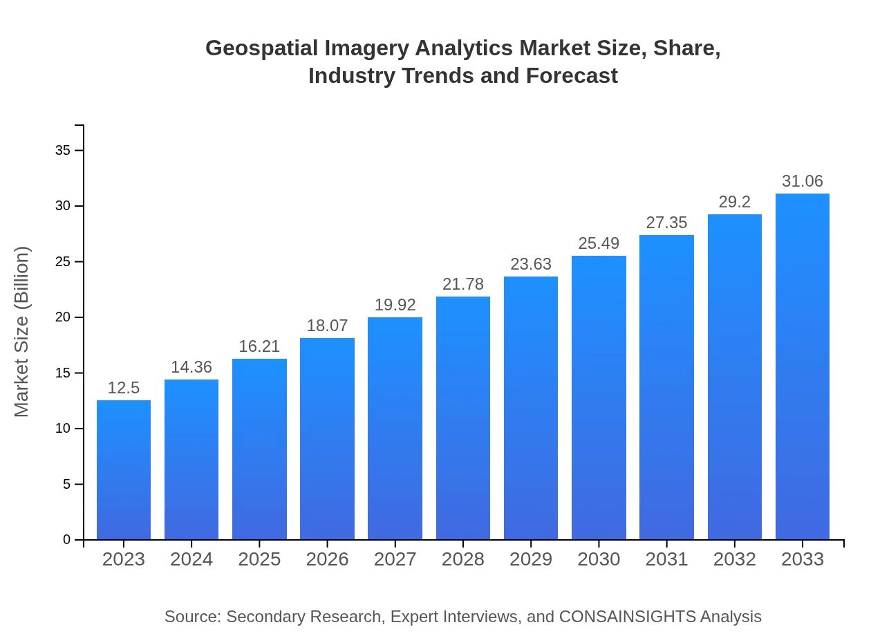
Geospatial Imagery Analytics Market — USD 12.5 billion in 2023, Growing to USD 31.06B by 2033 at 9.2% CAGR
This report provides a comprehensive analysis of the Geospatial Imagery Analytics market, detailing its growth trajectory, segmentation, regional insights, and trends from 2023 to 2033.
| Metric | Value |
|---|---|
| Study Period | 2023 - 2033 |
| 2023 Market Size | $12.50 Billion |
| CAGR (2023-2033) | 9.2% |
| 2033 Market Size | $31.06 Billion |
| Top Companies | Esri, DigitalGlobe, HERE Technologies, Google Earth Engine |
| Published Date | 24 September 2024 |
| Last Modified Date | 31 January 2026 |
Geospatial Imagery Analytics Market Overview
Customize Geospatial Imagery Analytics Market Report market research report
- ✔ Get in-depth analysis of Geospatial Imagery Analytics market size, growth, and forecasts.
- ✔ Understand Geospatial Imagery Analytics's regional dynamics and industry-specific trends.
- ✔ Identify potential applications, end-user demand, and growth segments in Geospatial Imagery Analytics
What is the Market Size & CAGR of Geospatial Imagery Analytics market in 2023?
Geospatial Imagery Analytics Industry Analysis
Geospatial Imagery Analytics Market Segmentation and Scope
Tell us your focus area and get a customized research report.
Geospatial Imagery Analytics Market Analysis Report by Region
Europe Geospatial Imagery Analytics Market Report:
In Europe, the market size is forecasted to increase from $3.58 billion in 2023 to $8.88 billion by 2033. The region's focus on environmental sustainability and regulatory demands for geospatial data utilization contribute to this growth.Asia Pacific Geospatial Imagery Analytics Market Report:
The Asia Pacific region is witnessing significant growth, with the market size expected to increase from $2.31 billion in 2023 to $5.75 billion by 2033. This growth is driven by rapid urbanization, government initiatives for smart city projects, and technological advancements in satellite imagery.North America Geospatial Imagery Analytics Market Report:
North America dominates the Geospatial Imagery Analytics market, anticipated to grow from $4.76 billion in 2023 to $11.82 billion by 2033. This growth is backed by strong demand from the defense, agricultural, and healthcare sectors, along with advancements in big data analytics.South America Geospatial Imagery Analytics Market Report:
In South America, the market is projected to rise from $0.58 billion in 2023 to $1.45 billion in 2033. The demand for geospatial analytics is fueled by growing agricultural sectors and investments in infrastructure development.Middle East & Africa Geospatial Imagery Analytics Market Report:
The Middle East and Africa market is expected to grow from $1.27 billion in 2023 to $3.16 billion by 2033, driven by regional investments in smart technology and urban development projects.Tell us your focus area and get a customized research report.
Geospatial Imagery Analytics Market Analysis By Platform

The Geospatial Imagery Analytics market is significantly influenced by different platforms. Desktop-based solutions occupy a substantial market share, projected to grow from $8.28 billion in 2023 to $20.56 billion by 2033, maintaining a 66.2% share. Meanwhile, mobile applications are growing rapidly, expected to reach $8.85 billion by 2033. Cloud-based solutions, though currently smaller, will see significant growth, reaching $1.65 billion in 2033.
Geospatial Imagery Analytics Market Analysis By Application
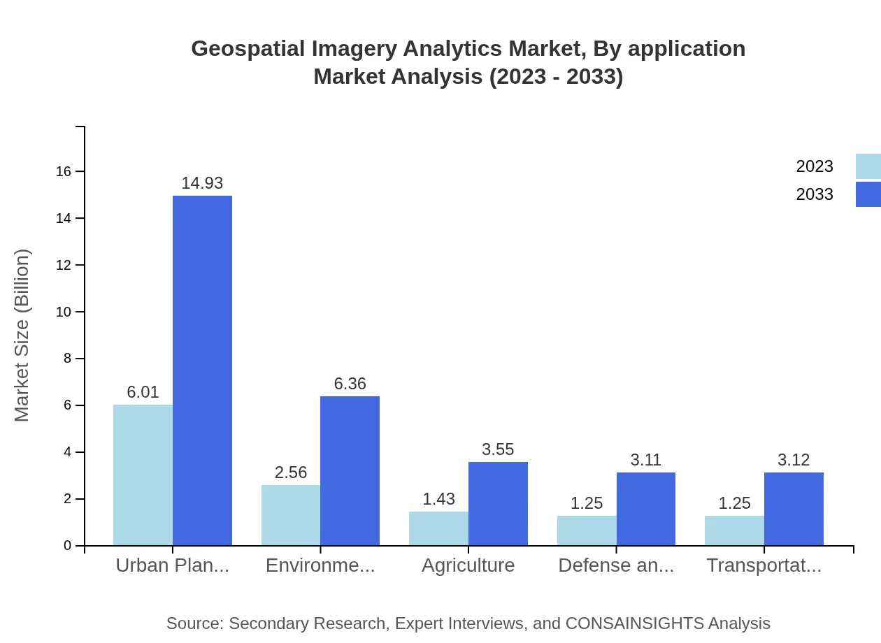
The application segment showcases robust growth across various industries. The urban planning sector leads with a market size forecast to grow from $6.01 billion in 2023 to $14.93 billion by 2033, holding a 48.07% market share. Environmental monitoring and agriculture are also significant aspects, projecting substantial increases to $6.36 billion and $3.55 billion, respectively, by 2033.
Geospatial Imagery Analytics Market Analysis By Technology
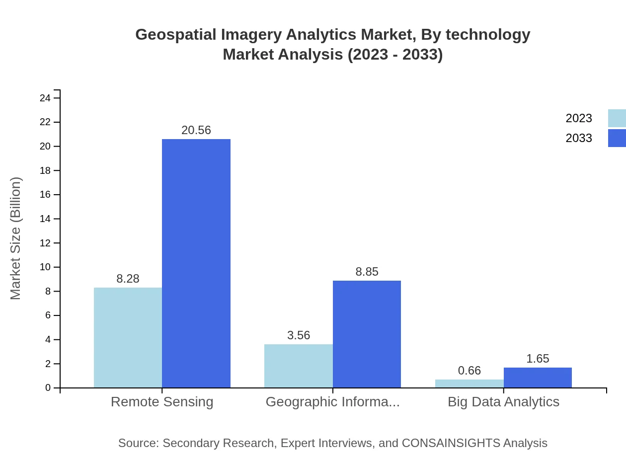
Technological advancements are central to the evolving landscape of geospatial analytics. Remote sensing technology dominates the market, expected to grow from $8.28 billion in 2023 to $20.56 billion by 2033, holding a 66.2% market share. GIS is also notable, projecting growth to $8.85 billion, supported by rising applications in various sectors.
Geospatial Imagery Analytics Market Analysis By End User
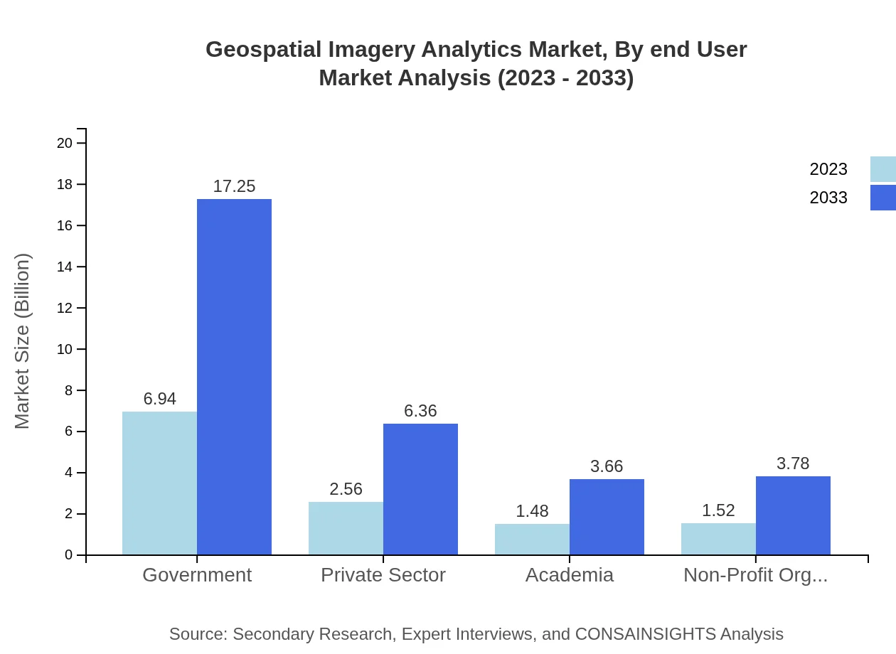
The Geospatial Imagery Analytics market finds itself closely tied to various end-users including government, private sector, and academia. The government sector will grow significantly, expected to reach $17.25 billion by 2033, securing a 55.53% share. The private sector is also on an upward trend, reaching $6.36 billion by 2033. Notably, academia, while smaller, indicates importance with expected growth to $3.66 billion.
Geospatial Imagery Analytics Market Trends and Future Forecast
Tell us your focus area and get a customized research report.
Global Market Leaders and Top Companies in Geospatial Imagery Analytics Industry
Esri:
Esri is a leader in GIS technology, providing innovative solutions for mapping and geospatial analytics across various industries.DigitalGlobe:
DigitalGlobe, part of Maxar Technologies, specializes in satellite imagery and analytics, serving defense, intelligence, and civil sectors.HERE Technologies:
HERE Technologies specializes in mapping data and location-based services, offering geospatial technology solutions across transportation and logistics.Google Earth Engine:
Google provides cloud-based geospatial data and analytics, enabling businesses and researchers to leverage satellite imagery for diverse applications.We're grateful to work with incredible clients.


FAQs
What is the market size of geospatial Imagery Analytics?
The geospatial imagery analytics market is projected to reach a size of approximately $12.5 billion by 2033, growing at a CAGR of 9.2% from its current valuation. This robust growth reflects increasing reliance on spatial data across various sectors.
What are the key market players or companies in this geospatial Imagery Analytics industry?
Key players in the geospatial imagery analytics industry include major tech firms specializing in artificial intelligence, remote sensing, GIS technologies, and software applications. Their innovations are driving the market forward, enabling enhanced data interpretation and application.
What are the primary factors driving the growth in the geospatial Imagery Analytics industry?
Growth in the geospatial imagery analytics industry is driven by increasing demand for location-based services, advancements in satellite and sensor technologies, and greater adoption of big data analytics across various sectors such as agriculture, urban planning, and environmental monitoring.
Which region is the fastest Growing in the geospatial Imagery Analytics?
North America is the fastest-growing region in geospatial imagery analytics, expected to grow from $4.76 billion in 2023 to $11.82 billion by 2033. Growing technology adoption and investments in infrastructure are key growth drivers in this region.
Does ConsaInsights provide customized market report data for the geospatial Imagery Analytics industry?
Yes, ConsaInsights offers customized market report data for the geospatial imagery analytics industry. Clients can obtain tailored reports that meet specific requirements and provide insights relevant to their strategic decisions.
What deliverables can I expect from this geospatial Imagery Analytics market research project?
Deliverables from the geospatial imagery analytics market research project include a detailed market report, executive summaries, competitive analysis, trend forecasts, and segmented analysis based on region and market players.
What are the market trends of geospatial Imagery Analytics?
Current trends in the geospatial imagery analytics market include increased integration of AI and machine learning for data analysis, the shift towards mobile applications for real-time data access, and growing investments in cloud-based solutions to enhance data sharing capabilities.